Roopkund Trek

8 DAYS - 7 NIGHTS (include all costs of the trek from kathgodam to kathgodam)
  • RoopKund_SumeruTourism
  • Roopkund6_SumeruTourism
  • Roopkund4_SumeruTourism
  • Roopkund2_SumeruTourism
  • Roopkund1_SumeruTourism
  • Roopkund_SumeruTourism

Region:- Uttarakhand
Max Altitude :- 15,700 Ft.
Approx Trekking Km:- 55 Kms.

A trek to Roopkund lake of Uttarakhand, i.e., Mystery Lake, is a must-do for an avid explorer! Battling several adversities shared with the Garhwal Himalayas, this water body perched in the laps of Mt. Trishul is located at an altitude of 16,500ft. Set amidst the compassionate mountainous peaks, the Roopkund Lake remains in the spotlight for its Mystery.
The adrenaline-pumping trek to Roopkund starts from Lohajung, a tiny pass seated at 16,500 feet above sea level in the Himalayas. This shallow lake has a depth of approximately 2 metres and is the most famous tal in the whole of Uttarakhand. Most gorgeous for the human skeletons lying at the bottom of the lake, which is specifically visible when the snow melts.
The way along the Roopkund trek is a captivating journey of discovering the most pristine of the Himalayan contribution of oak and blooming rhododendron forests. A moderate trek trails through mountainous rivers, enthralling ridges, lush forests and scenic meadows.

DEPARTURE/RETURN LOCATION Kathgodam
BEST SEASON May, June, September and October
DIFFCULITY LEVEL Moderate to Difficult
FIXED DATE Coming soon
DEPARTURE TIME Please arrive at least 2 hours before
INCLUDED
fare Accommodations
Breakfast and dinner All Meals from day 1
NOT INCLUDED
Entrance fees Mules and Porter to carry personal luggage
Guide gratuity Meals during road journey Insurance

1

Day 1: Pickup from Kathgodam and reach Lohajung (2300mts, 7500ft):

The journey will take not more than 9 hours, which includes one or two breaks. The twisting road goes through the region of Kumaon and covers the deep valleys of the Shivalik mountain ranges. The route will take you to Gwaldam. The way goes through forest and curves. Though there is a straight road from Gwaldam to Deval, the day’s final destination, it is not preferred due to damages at various spots due to the year long rains. The distance to be covered is small, around 10 kms, but it is better to way on a longer but the safer path through Tharali, which is about 36kms. About 2 hours of the drive will take you to Deval, a village with all provisions for purchasing food for the rest of the trip. The day’s last stretch of the trip is from Deval to Lohajung. The enormously curvy and winding road gains considerable height. The streets are so thrilling to drive on that sometimes, even the slightest of oncoming cars and trucks send Goosebumps. It is generally rainy and foggy most of the time, and temperatures remain very cold. The night is spent in a tourist rest house or nearby lodges.

2

Day 2:Lohagunj to Didna Village

The actual trek begins today. After an excellent home-prepared breakfast, the walk starts on the level ground with a slight ascent on the jeep road; the road goes to the village of Wan. An hour and a half pace on the level surface will take you to Kulling, located around 6km from Lohajung. Kulling is a village in the district of Garhwal, with a small population pool; it is filled with the beauties of nature. Exotic birds can easily be spotted; the air feels fresh. After Kulling, you take a right turn and steadily slope towards the village. At the start, you will notice a thin concrete plain which cuts through houses and fields and brings you to a small stream. Neel Ganga feeds this small stream. You descend further till you reach Neel Ganga. Go ahead and cross the bridge and hike the ridge on the right side of the bridge. The road forward is moderately steep and ends at the village of Didna, located at an elevation of 2450mts, 8000ft. The trail encompasses evergreen alpine forests, which are huge. After a climb of around 2 hours, you reach the top of the ridge; the view ahead is splendid. It is surprising to find substantial open lands at such a high altitude on the lap of the mountains. There are two villages very near each other, Didna and Kuling. They host the same type of trekkers. The first village is habited during summer and Monsoon, while the second one is popular during winter. The day’s trek is over at around 3 pm, after which a hot lunch is enjoyed. The total distance covered during the day is approximately 10kms, and the night is spent in a guesthouse.

3

Day 3:Didna village to Ali Bugyal

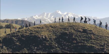
Today’s trek comprises trekking through the beautiful village of Ali Bugyal, which is located at an altitude of 3400mts or 11000ft; it is one of the highest inhabited locations in the india. Ali Bugyal is on top of the mountain and is noticeable from Didna. The hike will take you to climb on top of this mountain; after the start, the trail will take you out of the village. The course is slightly ascending on the right with a very mild gradient. On the way, momentary settlements of local shepherds known as Tolpani and their vast herds of sheep are a site to behold. They are very welcoming and warm in welcoming people; you can even share their lunch, which they think is a nice gesture.
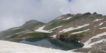
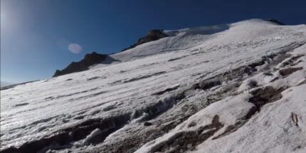
the trail on the left side is small in length but steeper. But it doesn’t matter which path you take; eventually, both will take you to the destination. Oak, Rhododendro and Birch, trees are the only trees that grow in these areas and are splendid and massive in size. According to natives, anyone visiting the place during spring can see the incredible view of the valley enclosed with thousands of Rhododendron flowers in vivacious colours, reaching the mountain top, the tree line gradually regresses, and the plain grasslands start. The climb takes around 3.5 to 4 hours. The Himalaya’s most attractive meadows, Ali Bugiyal, welcome you. The view is very alike to the default wallpaper of Windows XP and is a treat for the eyes. During the summer months, wild horses and cows graze the fields, filled with vast stretches of grass and flowers of various bright colours. In clear weather, it is calm to spot the peaks of Trishul and Mrighthuni, the tallest mountain peaks. The enormous Trishul beckons to be climbed upon and feels as if there is some hidden energy which attracts towards itself. After crossing the meadows, a small face comes on the way, and another 1.5 hour of trekking will take you to Bedn bugyal, the camping place for day 3. After that, visit the nearby temple in Bedni Kund..

4

Day 4:Ali Bugyal to Ghora Lotani

Today is the 4th day of the trek. You can choose to start a bit late and sleep a little extra. Your following camping location is Gora Lutani, a perfect camping place. Keep on walking and enjoy the attractive locations in the connecting area. Along the route, you will come across Patat Nacholi, a relatively new and vest able landmass. On this day, you will gain steep altitude from around 12,500ft to 14,500ft. The significant elevation and the long nonstop walks will make your legs hurt, and you will also start feeling the effects of the climate changes, and the thin air will make breathing difficult. But don’t worry; the beautiful surroundings will give you enough motivation to reach your destination. The positive vibes flowing in the air let you forget all your difficulties. After a travel of around 9kms, the campsite for the day is reached.

5

Day 5:Ghora lotani to Bhagwabasa

Wake up and brace yourself for the longest day of trekking. Have a breakfast, and don’t forget to do few stretches. Walk towards Bagubasa, located around 14050ft above the Mean sea level. This road will also take you across the Kalyuvinayak temple. The most thrilling part of seeing the temple is travelling up 2kms, which is equivalent to gaining an altitude of around 250ft. The route leading to this temple is very uneven and zig-zag in shape. It is necessary that proper safety gear and clothing are confirmed before the day’s trek is even started. The walk should be done very gradually and carefully; one small slip and anyone can get hurt very severely, the gifts await you at the top. It isn’t easy to understand how someone could create the temple at such a height. The temple is traditional in construction . The temple is engraved out of stones with accuracy and perfection; it installs divine intervention in your mind. From temple, you can view Roopkund, the final trekking destination. The view is magnificent, with shining and sparkling Trishul on one side and bell-shaped Nandagunti on the other. You follow up the uneven trail leading to Bhaguabasa at 1km from there.

6

Day 6:Bhagwabasa to Roopkund lake and back to Bedni Bugyal

Begin early morning to reach the destination – Roopkund. At an altitude of more than 16050ft, it is undoubtedly the highest peak on the trek. Though the path is not that complex to climb, even the 4km walk will take a breath out of you and exhaust you like hell. But no trekking is easy. During Monsoon, the snow covering area is very shallow, making the path reveal itself correctly. From Bhaguabasa, your initial checkpoint is Chhirianag which means ladder-like snake. From this place, the following path leads to Roopkund – The mystery island. The lake of skeletons is one of the most secretive places in the world. To date, even archaeologists and scientists are not able to find how many skeletons were on the lake bed. If you are fortunate, you can see somewhere around 300 human skeletons from the edge of the lake. This view is breathtaking, and people go crazy after seeing this.

7

Day 7:Bedni bugyal to Lohajung

Day 7 is possibly the last day of the trek, where you will have to walk and return to the campsit. it seems a modest way compared to the previous day’s tireless affair. After travelling a little more, you can see the road dividing itself into double lanes. You need to take the one which leads to the right and as you descend further, you can again see that you have entered the forest region. The birds tweeting and the cool aiwin past your ears are a treat you rarely get to feel. Due to the varying slope, explorers are cautioned to take every step very carefully; otherwise, they might end up hurting themselves. Shortcuts that may look rewarding must be avoided as much as possible as the terrain is rough. After walking a few more patches, you near an opening inside the thick forest called the Gahroli Patal. You continue our trip till you reach the banks of the river of Neel Ganga. Once you get to the river bed, your trip continues, till you touch the wan village.
The village of Wan is the next destination. Wan feels very much at home, a big village with hills and mountains covering the edges, a view to cherish all your lives. As you travel a few more yards on the road. The distance covered is approximately 20 km and requires about 9 hours. It needs 1 hour from Wan to reach Lohagunj. Once you return to the tourist guest house you can rejoice in all the trip memories and comfortably sleep on the warm bed.

8

Day 8:Lohajung to kathgodam

Today you will leave for Lohagunj; with attractive and unforgettable memories, pack your stuff and luggage. Your taxicab will drop you at the Kathgodam railway station. The car journey will take around 10 hours, so make sure you are carrying mint and tablets to prevent nausea. From Kathgodam, you will find trains to various locations. Board your respective train and take along an experience with memories that will never fade away.

Trek Essentials

Equipments

  • Backpack (Rucksack) (60 ltr -70ltr) with comfortable shoulder straps and back pack rain
    cover
  •  Walking Stick
  • Water Bottle
  • Head Torch with Extra Batteries
  • Lighter
  • Knife

Clothing

  • Down Jacket
  • Fleece Jacket
  • Windproof Jacket
  • Waterproof Trek Pants
  • Waterproof Jacket
  • Thermal Trouser
  • Woolen cap
  • Waterproof and Woolen Gloves

Gaiters

  • 5 Pair Woolen Socks &Light Cotton Socks
  • Hat
  • T-shirt 3-4
  • Comfortable Trek Pants 3-4
  • Handkerchief
  • Monkey cap

Foot Wear

  • Trekking Shoes
  • Slippers

Miscellaneous Items

  • Sun Block for Lips
  •  Sun Protection Cream
  • Sun Glasses it should be U/V Protected
  • Toilet Kit (Toilet Paper)
  • Quick Dry Towels
  • Water Purifying Tablets
  • Medical and First-Aid Kit
  • Hand Sanitizer

Other

  • Lunch box
  •  Buff
  •  Nail cutter
  • I.D.
  • Passport size photo

1 review for Roopkund Trek

  1. mintoo kumar gautam

    I have done roopkund trek with sumeru tourism. they have best guides. food served was awesome.

Add a review

Your email address will not be published. Required fields are marked *